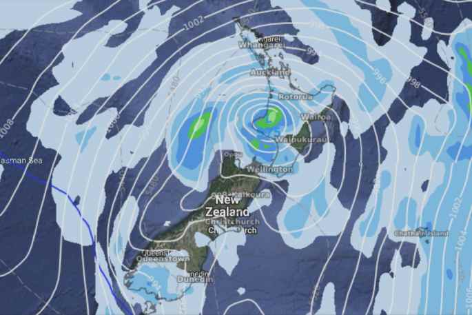
A deep tightly packed low is crossing over the North Island today moving in from the Tasman Sea. Winds around this low are quite strong and there will be areas of heavy rain.
For Northland, Auckland, Waikato and Bay of Plenty showers are expected with a chance of a heavy fall and thunderstorms.
In these four regions strong northwesterlies, tending a little more to the west are forecast for the afternoon with winds rising to gale or severe gale. Rain is due in the evening as winds tend strong to gale southwest. Temperature highs today for these regions range from 16-18 degrees Celsius.
Western North Island - including Central North Island:
Rain spreads in from the north during the morning with northeasterly winds, heavy falls for Taranaki then spreading elsewhere during the afternoon, the heaviest falls lie north of about Palmerston North. Thunderstorms possible for Taranaki. As a low moves in from the Tasman expect southerlies south of Taranaki becoming strong to gale about the coast, north of Taranaki winds come in from the northwest with gales. South to southwesterly winds take over in the evening with rain easing at night.
Highs: 13-18
Eastern North Island
Dry at first with sun then cloud thickens, spits of rain develop for Wairarapa around midday, turning to rain in the afternoon and becoming heavy as northeasterlies tend southwest. Heavy rain pushes northwards during the evening with southwesterlies (gales develop about the coast), heavy rain may not reach Gisborne but rain moves in none the less.
Highs: 16-20
Wellington
The odd shower then afternoon rain as southerlies strengthen, gales develop through Cook Strait. Rain eases back to showers in the evening.
Highs: 15-16
Marlborough and Nelson
Morning rain (heavy for Nelson and especially Tasman) eases to a few showers, drying up in the afternoon for Nelson then Marlborough by evening. Southeasterlies tend south to southwest in the afternoon, becoming strong about the Sounds.
Highs: 15-18
Canterbury
Showers, perhaps some rain from late morning. Southwesterlies freshen from afternoon.
Highs: 11-13
West Coast
Dry for South Westland, some high cloud. Cloudier further north with a few spits or showers, drying up a little in the afternoon but still the risk of a spit. Southeasterlies tend more southwest in the afternoon.
Highs: 14-17
Southland and Otago
Showers or a few areas of rain, clearing at night. Southerly winds.
Highs: 11-13

0 comments
Leave a Comment
You must be logged in to make a comment.