Thousands of homes are without power in the upper North Island and schools are closed in Coromandel as ex-cyclone Lola batters the regions.
More than 4000 Northland homes are without power as high winds continue to cause damage to lines in the region.
Several schools in Coromandel are closed due to the strong winds and rain battering the region.
Tairua School and kindergarten are closed, with the schools saying on social media they are concerned about the safety of staff and students when travelling.
Mercury Bay school in Whitianga said it was advised to close by Civil Defence.
Coroglen, Te Rerenga, Whenuakite and Opoutere schools were among those that decided yesterday to close today as a precaution.
Coromandel and Northland recorded 100mm of rain overnight with Gisborne ranges getting 29mm in one hour.
Strong wind and heavy rain warnings and watches remain in place for Northland, the Coromandel Peninsula, parts of Gisborne Tai Rāwhiti and Auckland.
The orange heavy rain warning covers Ūawa Tolaga Bay. The area's civil defence controller Greg Shelton told Morning Report things were beginning to "pick up" and he expected conditions there to be worst from mid-afternoon into Monday night.
"We're definitely not out of the woods," he said. His team would remain on standby until midday on Tuesday but everyone was "just hunkering down and watching" for the time being.
The forecast rain was more of a worry for the area than the wind, he said, but he acknowledged things could change fast.
"Anything from the northeast, things can change pretty quick."
He asked local residents to stock up on supplies now if they needed to, but to otherwise stay at home until the weather system had passed.
"Our river levels are pretty kind at the moment; we've gone through a wet winter and a dry August ... and at the end of the day a lot of people welcome this type of rain, provided we don't get too much, to keep the growth going and top up the water tanks."
*If you have photos of the weather in your area you can send them to SunLive at [email protected]
MetService recorded gusts of 130km/h in the upper North Island overnight
Strong wind caused damage to trees and power lines, Whangārei Mayor Vince Cocurullo said, though the rain hadn't been as bad as expected.
Power outages were widespread, with areas of Whangārei, Ruakākā, Parua Bay and towards Hikurangi losing lost supply.
"I have been getting feedback from different people around the community saying, you know that they've got trees across the road and things like that. So we're getting the contractors out there at the moment.
"As people are travelling and coming to school, the biggest thing I'm just asking people to do is just drive safely and just remember that the roads are a changing environment."
Auckland Harbour Bridge was operating with four lanes in each direction during Monday morning's peak and speed restrictions were expected, Waka Kotahi said.
Strong winds have also prompted Waka Kotahi to operate Auckland's Harbour Bridge at lower capacity.
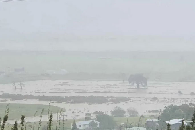
Impact of king tides in Coromandel
All eyes are on the Kauaeranga River in Thames-Coromandel District as this morning's king tide arrives.
The area's civil defence controller Garry Towler told Morning Report the river, which passes under State Highway 25 just south of Thames, was "very close to over-topping".
If that happened, both SH25 and some other roads would close, he said.
However the Kauaeranga River often flooded and Towler was confident any breach of its banks would be well managed.
"It's a designated flood plain .... there's a freedom camping park right next to it and we've already moved about 20 campers off there this morning," he said.
"It is what it is ... a lot of rain is coming down out of the hills and it just has to flow out."
Towler said Brophy's Beach, north of Whitianga township was closed and civil defence was keeping an eye on a number of other "very low-lying" roads between Whitianga and Whangamata that would likely be impacted by the king tides over the next two to three hours.
He was not expecting any evacuations to be necessary and said the area had built a lot of resilience since Cyclone Gabrielle.
"We've fared a little bit better than we possibly thought last night," he said.
"This storm has moved through a lot quicker than we originally thought, so I would say possibly by the end of play today we will start to see some blue skies and the wind will drop away and we can start cleaning up."
The tail of ex-Tropical Cyclone Lola, which caused extensive damage as it smashed through parts of Vanuatu earlier this week, has merged with another trough as it crosses the upper North Island.
MetService warned people coastal communities in the upper North Island to beware of high swells, as strong onshore winds combine with a king tide on Monday morning.
Waves of 4.9m were recorded in the Bay of Islands overnight, MetService meteorologist Mmathapelo Makgabutlane said.
Wind gusts of 130-140km/h hit exposed areas of the upper North Island overnight, while Whangārei had gusts of 90km/h.
Kaikohe had 138mm of rain over 24 hours to Monday morning, she said.
The windy weather will continue through Monday, with the weather system moving eastwards, Makgabutlane said. There are orange heavy rain warnings or watches for Coromandel Peninsula and Tai Rāwhiti/Gisborne, and a strong wind warning for Coromandel Peninsula.
"On Tuesday we are expecting a general easing in that weather," she said.
"Midweek and into the second half of the week we are expecting another system to come in from the west so definitely a good week to keep an eye on the latest watches and warnings on metservice.com"

0 comments
Leave a Comment
You must be logged in to make a comment.