.jpg)
Freezing air from Antarctica is spreading up the South Island and lower North Island on Monday before being quickly pushed eastwards out over the Pacific Ocean from an incoming high pressure zone out of Australia.
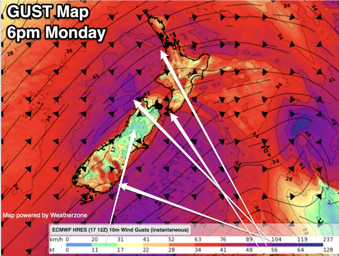
With a large low spinning south-east of NZ and the incoming high, WeatherWatch says it means windy weather will continue over NZ for Monday and even Tuesday for some, helping to dredge the cold weather northwards.
Snow:
Snow flurries, heavier inland on the hills and ranges and higher elevations, continue over Monday in the South Island, says a statement from WeatherWatch.
"Just like rain showers, snow showers can line up in one area and bring greater totals - or the hills and ranges may shelter you from much, if anything at all. Snow to sea level is possible around the Catlins and up to about Dunedin City.
"It may fall elsewhere in Southland and Otago to sea level or near sea level (down to 50 or 100m) - but, it's not likely to settle long or build up to much in most instances.
"In fact snow totals from this event are generally not too much - but in NZ it doesn't much snow and ice to cause travel problems in particular, due to our hilly terrain.
"Snowy areas remain around some parts of Canterbury too, although generally not so exposed on Monday as Southland and Otago are due to the south-west lean in airflow."
Some snow moves into the North Island on Monday night and Tuesday morning
48 Hour #Snow Map: North Island.
— WeatherWatch.co.nz (@WeatherWatchNZ) August 18, 2024
This map shows snow on SH 1, The Desert Road, Monday afternoon and into Tuesday morning (where black ice may also be an issue).
🏂⛷️And yep, snow on the North Island ski fields, with heaviest falls on Mt Ruapehu.
Updated 4pm Sunday. pic.twitter.com/9Q3ltyEoWk
Gales:
There's a reason why forecasters offer return to these as "Antarctic Blasts" - it's full of gale force weather as well as the cold, says a spokesperson for the weather organisation.
"Gales or even Severe Gales may brush exposed coastal and alpine areas of both main islands as the cold 'pop' of polar air moves northwards, and another air mass out of Australia shifts in and merges with it.
"The high pressure zone out of south-eastern Australia is big (as they so often are in August) and is going to squeeze windy weather over New Zealand as it gets nearer.
"View when winds peak by using the "Trends" feature in our free app and at RuralWeather.co.nz... or use the hourly data at WeatherWatch. It's the easiest way to visualise the general start, peak and end of windy weather (and rain, temperatures, fog, cloud, etc too)."
Temperatures:
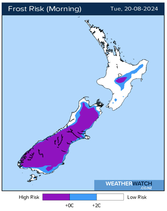
For some South Island places temperatures started dropping across Sunday during the daytime, and won't stop dropping until after sunrise on Monday, says WeatherWatch.
"A total of about 18 hours of the mercury falling. As that high pressure zone comes in from Australis and winds ease inland, those temperatures will fall even lower on Monday night/Tuesday morning with heavy to severe frosts possible around the South Island and some lighter frosts into the North Island."
Livestock
Snow totals hopefully will be on the lower side of things for this event for most, but it's worth noting in Southland, Otago, Canterbury and some high elevation parts of the central to eastern North Island snow might become heavy enough to be problematic - see MetService warnings here.
WeatherWatch says the latest snowfall maps show some areas of build up, but mostly around the main hills and ranges.
"As it so often is due to our temperate climate in NZ, and then our mountains and ranges, snow and winds can vary from community to community, region to region - but wind chill will be miserable for newborn lambs and calves on Monday and some further north may have wet (raining but not snow but close to it, which can be worse for newborn animals), cold, conditions and biting wind chill, plus hail showers for some too.
"Overnight Monday and into Tuesday temperatures may plummet inland, especially in the South Island, with -5 to -10 degrees possible in the high country.
"The positive about this event is it's short lived in nature with Monday morning through to Tuesday morning being the coldest period. Moisture levels aren't too huge either, and milder weather returns quickly this week (especially by day)."

0 comments
Leave a Comment
You must be logged in to make a comment.