After a blustery and thundery weekend, a few more days of unsettled weather is being forecast before a ridge of high pressure brings relatively settled weather across the country in the second half of the working week.
Temperatures are also set to drop as skies clear in the overnight periods, warns the MetService.
Over the weekend, a Severe Thunderstorm Watch was issued for western parts of the North Island, and the Marlborough Sounds, for Saturday night into Sunday morning.
"Around 93,400 lightning strikes were recorded from midnight on Friday to 6am on Monday, with around a quarter of those occurring over land," says MetService meteorologist Alwyn Bakker.
"Rain intensities peaked at 15mm/h for most affected regions, with some areas seeing 20 to 25mm/h. However, once the majority of the thunderstorms cleared on Sunday morning the weather improved significantly for much of the country, with temperatures reaching the high teens to low twenties in both main islands."
The unsettled weather is set to continue on Tuesday. Strong northwesterlies are expected about central and southern parts of the country, with fronts bringing a burst of heavy rain to many western areas.
Heavy Rain and Strong Wind Watches and Warnings have been issued for the lower South Island, the Canterbury High Country, and Wellington and southern Wairarapa.
"We advise people to keep up to date with the latest forecasts, as spring weather is notoriously changeable,” warns Bakker.
"Thunderstorms are also possible for parts of the South Island, and also coastal Taranaki to northern Wellington on Tuesday."
Behind the strong northwesterly winds and heavy rain, is a push of southwesterly winds which will bring a noticeable drop in temperature on Wednesday and Thursday – especially in eastern areas.
Looking further ahead, a ridge over the Tasman Sea starts to extend over New Zealand on Wednesday, driving away most of the poor weather and lowering overnight temperatures.
Frosts will be possible in parts of the South Island and inland North Island, along with snow for higher passes.
Make the most of any settled weather this week as another bout of wind and rain is lined up for the weekend.
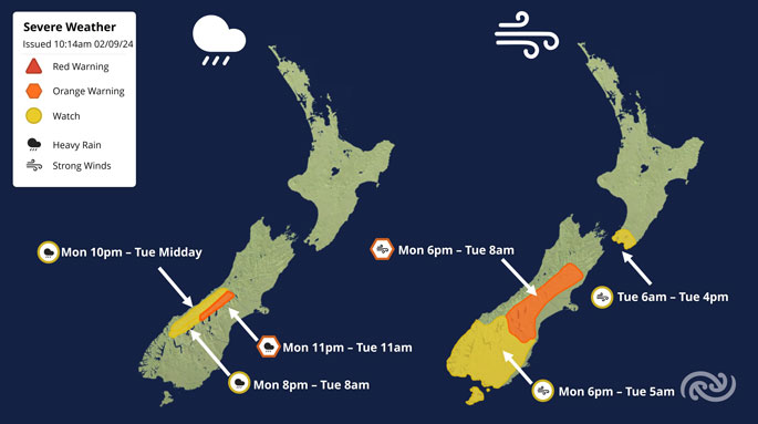 Image: MetService.

0 comments
Leave a Comment
You must be logged in to make a comment.