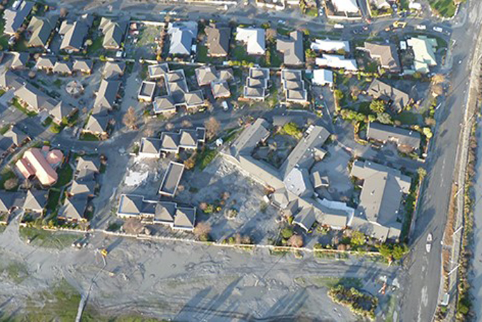
Throughout the months of August and September a city-wide liquefaction hazard study will be carried out.
During this time you may see a small vehicle mounted test rig pushing a test cone about 10 meters into the ground.
This will give the Tauranga City Council data on how likely the ground is to liquefy when an earthquake occurs.
Tauranga City Council resilience specialist Steve Raynor says the information the council will receive once the study is completed will be made public so that everyone can understand the risk to them and their communities.
'The output from the study will estimate the ground damage that will result from an earthquake. Reliable output is dependent of detailed analysis of high quality information regarding:
Soil type – this is obtained from the testing that is happening now. A lot of data is also held from previous projects.
Ground water level – groundwater monitoring has significantly improved this year and a digital model of this will be created.
Ground Surface level – a detailed surface level survey was done early this year.
Earthquake shaking – a new study this year has provided estimates of shaking.
Underground geology – this is being mapped as part of the liquefaction study.
Climate change – projections of sea level rise are a key input into the liquefaction estimates which consider conditions out to 2130.
'Experts will spend several months analysing the information to determine liquefaction damage under different conditions at different times in the future.”
Steve says now is a good time to carry out the study as they have sufficient new and detailed data to provide an accurate projection of liquefaction hazard to the city.
'In 2003, the Western Bay of Plenty Engineering Lifelines Group assessed the liquefaction potential of Tauranga and the wider sub-region. This work identified where and under what circumstances liquefaction may occur at a broad regional scale.
'We are now working to improve our knowledge of liquefaction in Tauranga, and to better understand the risks and consequences of an earthquake occurring. This study is quite complex as it requires an analysis of the ground shaking that might occur in an earthquake, followed by determination of where and how much liquefaction may occur.
'This can then be translated into estimated ground damage and its likely effect on buildings and infrastructure.
'The science of liquefaction and the engineering in response to liquefaction ground damage has been significantly advanced since 2010 thanks to the Christchurch earthquakes.
'Extensive studies in other areas such as ground water and earthquake shaking have made it possible for us to get high quality results.”
Steve says the study will enable the council to focus design and construction efforts to build resilience into the city infrastructure.
'That means making the roads and water supply strong enough to survive an earthquake.
'This will be added to other hazards we are studying to reduce the risk of damage and loss of life posed by the natural elements. This is called the City Resilience Project.”


1 comment
Hope
Posted on 14-08-2019 16:11 | By Feruno
I sincerely hope this activity is not going to cause loss of communications, water,power, or any other underground services the 'cone' can cut or make a hole in. I would be VERY surprised if some 'not on modern records' cable or pipe is damaged.
Leave a Comment
You must be logged in to make a comment.