It is glass half empty or glass half full when it comes to La Nina, which has officially come to an end according to the Bureau of Meteorology.
The Australian public agency yesterday said this event has ended - but while the second La Nina event in a row has now finished, the global modelling suggests a third La Nina is coming (known as a 'triple-dip La Nina').
"If you were to look at the international modelling, without knowing La Nina had just ended, you'd be talking about how La Nina is developing," says WeatherWatch.co.nz head forecaster Philip Duncan.
"This is what we mean by glass half empty or glass half full. Yes, this second La Nina event has officially finished, but the data and modelling supports La Nina potentially returning for a third time in just a few months."
Scientists from Australia and the USA agree about a third La Nina on the cards.
"The 2021–22 La Niña event has reached an end, with a majority of indicators currently at neutral levels" says BoM in a statement on their website.
"However, some model outlooks suggest La Niña may re-form later in 2022. As a result, the Bureau's ENSO Outlook status has moved to La Niña WATCH.".
A La Niña WATCH means there is around a 50 per cent chance of La Niña forming later in 2022. BoM says this is approximately "double the normal likelihood".
BoM says most climate models surveyed by them indicate neutral conditions through the southern hemisphere winter, but that four of the seven models surveyed suggest La Niña could return this spring, with the remainder of models persisting at neutral ENSO levels.
Philip says New Zealanders should monitor developments, but also remind ourselves we're a long way from where La Nina is measured.
"While news media and other forecasters can focus on La Nina bringing floods - and in isolated pockets we have seen flooding this year - it's important to note the past two La Nina events for New Zealand also brought large areas of drought into both main islands."
Philip says it's not always clear cut for NZ due to our location halfway between the tropics and Antarctica but certainly La Nina events bring an increased chance of warmer than average weather to NZ and the risk of the odd big rain event.
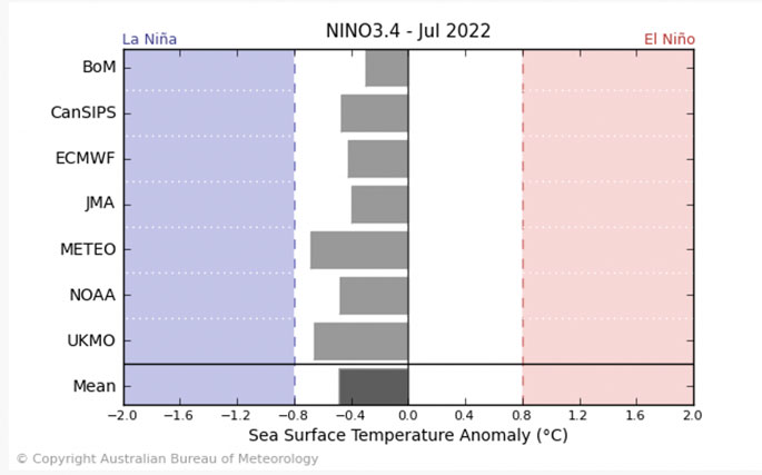 Public global models BoM uses to help with decision making.

Current Sea Surface Temperatures (SST) anomaly map.
Map courtesy BoM.

0 comments
Leave a Comment
You must be logged in to make a comment.